(Striking through the undersea nations stuff until I figure out what to do with them, as I don't want to scrap the concept entirely.) Tag: Visual edit |
No edit summary Tag: Visual edit |
||
| Line 87: | Line 87: | ||
*What's shown on the map is known as "Maritymir proper"; the Maritymiri Ocean technically ends at the eastern shores of Ingdjiva, the western shores of Nekcroz, and at the grand line to the north. |
*What's shown on the map is known as "Maritymir proper"; the Maritymiri Ocean technically ends at the eastern shores of Ingdjiva, the western shores of Nekcroz, and at the grand line to the north. |
||
**The waters that extend into the southward across the South Pole are called the Eluoec Sea, which is considered separate from the main ocean. |
**The waters that extend into the southward across the South Pole are called the Eluoec Sea, which is considered separate from the main ocean. |
||
| − | *The waters within the Waikiki Archipelago, which is divided between Hawaiki and the Hispanian and Dongbalian colonies, Islas del Dragon and the Cuicao Islands respectively, is believed to be the homeland of Iekika Ka'aukai, the first |
+ | *The waters within the Waikiki Archipelago, which is divided between Hawaiki and the Hispanian and Dongbalian colonies, Islas del Dragon and the Cuicao Islands respectively, is believed to be the homeland of Iekika Ka'aukai, the first [[Abjaksan]] of the great ocean. |
*The reason Majapahit is mostly cut off on the map is because most of the archipelago is situated closer to Ingdjiva. |
*The reason Majapahit is mostly cut off on the map is because most of the archipelago is situated closer to Ingdjiva. |
||
*Although not shown on the map, thousands of small islands and mini-archipelagos dot the surface. However, some periodically vanish beneath the waves and then reappear some time later due to the water levels constantly rising and falling. |
*Although not shown on the map, thousands of small islands and mini-archipelagos dot the surface. However, some periodically vanish beneath the waves and then reappear some time later due to the water levels constantly rising and falling. |
||
Revision as of 23:25, 20 February 2020

|
The owner of this page is SkyGuy. According to policy, no other user, with the exception of admins, may edit this page without the owner's permission. |
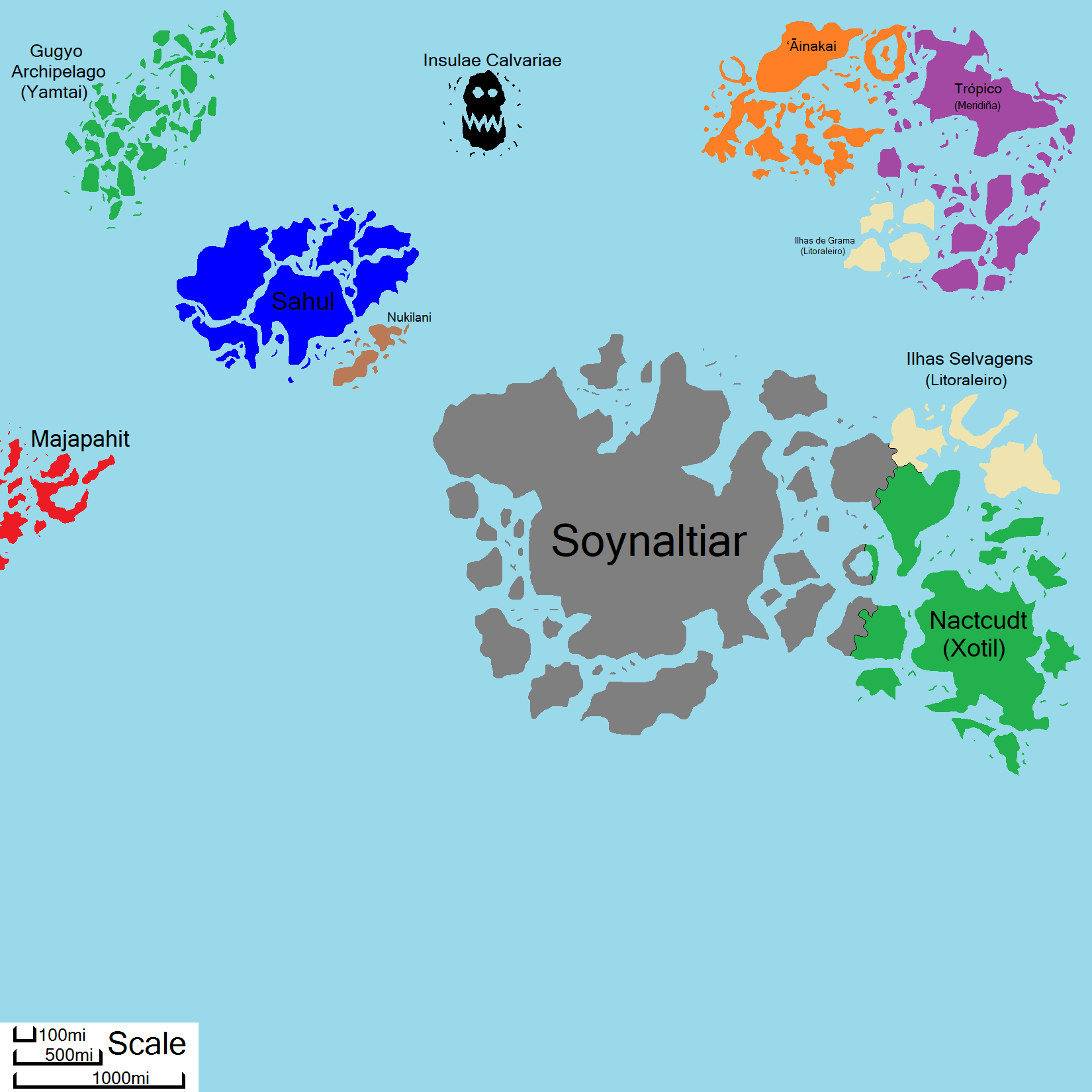
The Maritymiri Ocean, or simply Maritymir, is the southeastern ocean of Qirsyllviar.
Sovereign States
Empire of Atlantis
Capital: Kelboe
Government: Hereditary Absolute Feudal Monarchy
Head of State: Emperor
Head of Government: Emperor
Legislature: None
Demonym: Atlantian
Currency: Gems
Atlantis is an island nation in central Maritymir, taking up the whole of the island continent of the same name, the many islands surrounding it, and a portion of the eastern islands known as the Wildlands.
Eastward, it shares land and maritime borders on three islands: Elapardris, the southern island; Darkatisyol, the small ringed island; and Zantyonas, the larger northern island. On Elapardris and Darkatisyol, Atlantis solely borders the colonial province of Xotil, Nactcudt; but on Zantyonas, Atlantis borders Nactcudt to the east and the Lusitanian colonial province of Ilhas Selvagens to the north.
One of the oldest continuous nations on Qirsyllviar, and currently ruled by the Kyiida Dynasty, Atlantis, like Xotil, is also the site of where a strange craft made of stone and metal crashed into the earth. It is presumed to be the same sort that crashed in Nekcroz, but this one crashed at least a thousand years earlier. The Atlantians of the time since salvaged the strange technology and used it to make their homeland prosper, and became the first nation, until Xotil, to master flight without magic or beast-riding.
Unlike Xotil, Atlantis had no interest in expanding beyond their island's borders, and so stopped using the salvaged technology for conquest once Atlantis achieved dominance over the Atlantian homeland and surrounding islands; regardless, Atlantis has still been known to resort to war and invasion to achieve demands or repel threats.
The island continent Atlantis occupies used to be much larger, with additional land to the southwest, and east; the Wildlands were also once part of the whole. But, an accident during a civil war known to history as Kanjiniro-Tografik War (a civil war between two dynasties competing for the throne following the extinction of the Hoklorac Dynasty), caused by ill-tampering with the alien technology, resulted in a cataclysmic disaster known to Atlantian history as the Great Ketellaao. The Great Ketellaao is described in ancient texts as a massive earthquake that shook the land for fourteen full days, and created many tsunamis, some nearly two miles high. The devastation resulted in over half of Atlantis's original lands, mostly lands to the southwest and the east, breaking off and moving further out, becoming large subcontinental islands outlying the mainland, the Wildlands being one prominent example. Some of the former whole didn't survive the disaster and sank beneath the waves, particularly lands which used to be northwestern continent and some lands that were once between the current islands. Some smaller islands that existed before the disaster also sank. The few small islands that didn't sink beneath the waves simply moved further out. The Great Ketellaao reportedly affected other lands around Maritymir, but this is unconfirmed.
After the Great Ketellaao, Atlantis on the mainland collapsed into at least seven different independent states and didn't reunite into a single state for at least three centuries. But, even with reunification, the Atlantis all but abandoned administrating most of the eastern lands while it rebuilt the mainland, paving way for several other new nations to form in absence of the Atlantian government; at least until the invasion and colonization of the Wildlands by Xotil and Lusitania.
Kingdom of Hawaiki
Capital: Pu'uwai Village
Government: Hereditary Feudal Monarchy
Head of State: Ali'i Nui
Head of Government: Ali'i Nui & Noho Ali'i
Legislature: Noho Ali'i Council
Demonym: Hawaikian
Currency: Shells
The Kingdom of Hawaiki is a monarchical archipelagic state in northeastern Maritymir, occupying the western half of the Waikiki Archipelago, sharing the archipelago with the Hispanian colonies of the Islas del Dragon to the east.
In the northeast of the nation is the ring island of Akua Mokupuni. The island in the center is Ola ʻUhane, in the center of which is a vast ancient temple believed to house the tomb of Iekika Ka'aukai.
Mostly descendants of exiles and immigrants from the nearby island nations and the undersea kingdoms, Hawaiki is a country where Humans and Merfolk co-exist side-by-side. As part of the Waikiki Archipelago, Hawaiki is sometimes also referred to as paradise due to its near isolation from the rest of the world, and the waters remain pure and untouched, allowing the tradition of surfing.
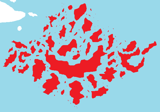
Empire of Majapahit

Capital: Wilwatikta
Government: Hereditary Absolute Feudal Monarchy
Head of State: Raja
Head of Government: Mahapatih
Legislature: none
Demonym: Majapahitan
Currency: ???
The Empire of Majapahit is an archipelagic nation of Ingdjivan origin in western Maritymir, occupying the Kejawen Archipelago. Majapahit shares maritime borders with no other nation in Maritymir.

The whole of Majapahit
Majapahit was once known as the Empire of Srivijaya. After the said empire fell, the archipelago became divided between the kingdoms Kediri, Singhasari, Kahuripan, Sunda, Galuh, and Medang, all vying for land power, a time in Kejaweni history known as the Six Kingdoms Period. This period of back and forth territorial expansion and recession ended when all six kingdom were reassimilated into a single empire through a treaty of union.
Kingdom of Nukilani
Chiefdom of Sahul

Capital: Sahul Village
Government: Confederate Hereditary Absolute Monarchy
Head of State: High Chief
Head of Government: High Chief
Legislature: None
Demonym: Sahuli
Currency: n/a
The Chiefdom of Sahul is a large monarchical island nation in northwest Maritymir, occupying the island of the same name and many more. It shares maritime borders solely with Nukilani, its suzerainty, to the southeast. Sahul was allegedly part of the Atlantian mainland before the Great Ketellaao, but whether of not this is true is unclear.
Undersea Nations
There are five existing undersea nations of merfolk and other sea-dwellers around Maritymir.
Chiefdom of Bivalvia
Capital: Bivalve Village
Government: Hereditary Monarchy
Head of State: High Chief
Head of Government: High Chief
Legislature: Council of Bivalvia
Demonym: Bivalvian
Currency: Shells
Bivalvia the undersea nation in northwestern Maritymir, bordering the territorial waters of Hawaiki to the northeast, the Kappa Islands to the northwest, and Majapahit to the southwest.
Kingdom of Chelonii
Kingdom of Cnidaria
Chiefdom of Delphinidae
Empire of Mysticeti
Constituent Territories
Viceroyalty of Ilhas Selvagens
Capital: Las Selvagens
Government: Hereditary Parliamentary Feudal Monarchy
Head of State: King of Lusitania
Head of Government: Viceroy
Legislature: Council of Las Selvagens
Demonym: Selvagenian
Currency: Cruzado
The Viceroyalty of Ilhas Selvagens is an archipelagic colonial province of Lusitania in the northern side of the archipelago, known as the Wildlands, in southeastern Maritymir. On the island of Zantyonas, the larger western island, it borders Nactcudt, a colonial province of the lizardfolk Xotilic Empire, to the south, and the Empire of Atlantis to the southwest; and via the island of Angelos, the eastern island, it shares maritime borders solely Nactcudt to the south.
Viceroyalty of Islas del Dragon
Capital: Ciudad Dragon
Government: Hereditary Parliamentary Feudal Monarchy
Head of State: King of Hispania
Head of Government: Viceroy
Legislature: Council of Ciudad Dragon
Demonym: n/a
Currency: Doubloon, Escudo, Reale, Picayune
Islas del Dragon is an archipelagic colonial province of Hispania in northeastern Maritymir, occupying the eastern half of the Waikiki and Dragon Archipelagos. It shares maritime borders with Hawaiki to the west and the Cuicao Islands to the southwest.
Kappa Islands
Capital: Kissuiso
Government: Imperial Appointed Magistracy
Head of State: Emperor of Yamatai
Head of Government: Bugyō
Legislature: Council of Kappa
Demonym: Kappese
Currency: Hansatsu, Koban, Nibuban, Ichibuban, Tsuho
The Kappa Islands, is an archipelagic colonial kuiki of Yamatai, occupying the archipelago of the same name in northwestern Maritymir. It shares maritime borders solely with Bivalvia to the southeast.
Province of Nactcudt
Capital: Shorx
Government: Theocratic Absolute Monarchy
Head of State: Da'phyndor of Xotil
Head of Government: Da'phyndor of Xotil
Legislature: none
Demonym: Nact
Currency: Erniga
The Province of Nactcudt is an archipelagic lizardfolk colonial province of the Xotilic Empire in southeastern Maritymir, occupying the majority of the archipelago known as the Wildlands. Its capital resides on the large island of Zounkla.
On the island of Zantyonas it borders the Lusitanian colony Ilhas Selvagens to the north and the empire of Atlantis to the west. It also borders Atlantis to the west on two other islands, the ringed island of Darkatisyol and the island of Elapardris.
It is the only territory in Maritymir colonized by a Nekcrozi power.
Cuicao Islands
Capital: Longcheng (龍城)
Government: Imperial Appointed Magistracy
Head of State: Zuigao Bazhu of Dongbalian
Head of Government: Zongdu
Legislature: Zongdu's Council
Demonym: n/a
Currency: Jiaozi, Guanzi, Huizi, Jinlong, Yinhu, Tongying, Tiegui
The Cuicao Islands (龍群島) are an archipelagic colonial province of Dongbalian in northeastern Maritymir, occupying the western half of the Dragon islands, the southern islands of the whole Waikiki Archipelago. It shares maritime borders with Islas del Dragon to the east. It was established as a result of Dongbalian's continuous expansion south following the conclusion of the wars with Tianchao. It is the only territory in Maritymir colonized by a Marlakcese power.
Neutral Territory
Insulae Calvariae

Insulae Calvariae is a pair of skull-shaped islands in northern Maritymir, halfway between the Kappa Islands and Hawaiki. It is, by a mutual unwritten agreement between nations, neutral ground.
In exploitation of this, pirates from all over Qirsyllviar have made it a haven for hiding out and the island has long been feared to house the souls of the dead that never passed from the world. Other myths say that these islands house a passage to the underworld. But this has yet to be proven either fact or fiction, as no one, not even the pirates that use the island, has ever ventured into the lower bowels of the islands for thousands of years.
Notes & Trivia
- The demonym for people from Maritymir is "Maritymiri".
- What's shown on the map is known as "Maritymir proper"; the Maritymiri Ocean technically ends at the eastern shores of Ingdjiva, the western shores of Nekcroz, and at the grand line to the north.
- The waters that extend into the southward across the South Pole are called the Eluoec Sea, which is considered separate from the main ocean.
- The waters within the Waikiki Archipelago, which is divided between Hawaiki and the Hispanian and Dongbalian colonies, Islas del Dragon and the Cuicao Islands respectively, is believed to be the homeland of Iekika Ka'aukai, the first Abjaksan of the great ocean.
- The reason Majapahit is mostly cut off on the map is because most of the archipelago is situated closer to Ingdjiva.
- Although not shown on the map, thousands of small islands and mini-archipelagos dot the surface. However, some periodically vanish beneath the waves and then reappear some time later due to the water levels constantly rising and falling.